


Much of the perception we have on territory, oceans, and continents comes from maps. Images that become accepted representations of reality with time and are almost never questioned. Today, tools to interact with maps from certain places are increasingly accessible and with them, the diffusion of new perspectives of space.
Maps are much more than a geographical representation, for centuries they were tools through which spatial reality was shaped. Mapping translates the essence of the ideology and progress of its time and its chronology shows the evolution of civilization. It is an effective tool to express concepts of space and boundaries graphically, among other variables. It was expected that with the arrival of new technologies, our spatial perception would broaden and find ways to defy previous ideas. With practices such as counter-mapping and the use of GIS (Geographic Information Systems), mapping has raised utilities outside the discipline of Geography.
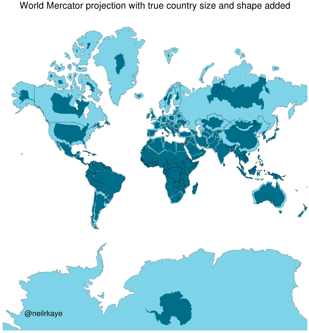
Counter-mapping is a branch of Cartography, which defies preset spatial ideas through alternative maps. One example is the Mercator projection, the map with the greatest diffusion since the 16th century. Its purpose was to make surfing easier, since it respected orientation through cardinal points. The opposite of this image emerges from the dimensional distortion of areas like North America, Europe, and Russia. From the perspective of critical geography, it is considered that its diffusion indirectly promotes Eurocentric ideas. In the following representation by Neil Kaye, we can compare the real size with the distortion of the Mercator projection.
The debates related with unilateral cartographies are the graphic distribution of territories in conflict. Jammu and Kashmir is a conflicted area between India and Pakistan, and since there is no resolution, maps from both countries claim its property. Taking these conflicts into consideration, authors and cartographers have pushed studies on mapping and social cartography, thus allowing people living in conflicted territories to express their spatial perception and sense of belonging.
Along with different lines of thought, the development of new technologies was one thing that transformed cartography. The planet’s spherical image was no more than a notion, until the discovery of satellite photography. By the hand of this progress in commercial access to software that manages GIS, the panorama opened to anyone who had access to a computer. Today, maps are not restricted to geopolitical territories, the possibilities of spatial information visualization have expanded to demographic data, infrastructure, communication, among others and with this, the capability of getting different perspectives.

One huge limit for traditional maps is their lack of contextualized information on links. Parag Khanna, International Relations Analyst, explains that territorial connections are clearer when they are seen through a night satellite map. Khanna says that the study on planning would increase their potential if functional and not political geography was employed. Studying the connectivity patterns between big cities would be possible to foresee urban infrastructure needs, overcoming obstacles like political limits. A good example of infrastructure based on functional connectivity is the bridge connecting Tijuana with San Diego.
Accessibility to information and making the use of cartographic tools easier has democratized this discipline. The creation of collective participation maps simplifies communication, no only between communities, but also with government organizations. An example of this was the Mexico City platform during the days following the earthquake on September 19, 2017, allowing every inhabitant to report damaged structures and areas that required priority attention. Unlike the map of seismic areas, this map served to communicate inhabitants, organize brigades, and offer spatial orientation in a time of crisis.
Breaking paradigms created from lack of information, like cultural stereotypes is one of the benefits of the Voyager photomaps, developed by Google Earth, which has allowed for global users to upload images and virtual tours. Gopal Shah, Production Director, says that it is through this kind of map that each person is able to share something about homeland roots, creating empathy.
Everyone has searched for their home using this program. With this project, imagine being a kid and being able to enter a Peruvian household or a Mongolian yurt..
